In November 2018, the Woolsey Fire swept through Malibu and the surrounding area with the speed and indifference that anyone who has been through a wildfire knows. We were based in Malibu. We lost personal possessions. We lost our home. We lost the physical location of Drone Tech Aerial. The business burned down.
We rebuilt. That process took time, money, and the kind of sustained effort that is hard to explain to someone who has not had to do it. But the rebuild also gave us something that no credential or certification could: a complete, first-hand understanding of what wildfire loss actually involves, as a property owner, as an insurance claimant, and as someone who eventually engaged with the legal process and successfully litigated a claim.
That experience is the reason we now offer wildfire documentation services to homeowners and the law firms representing them. Not as an add-on to our film work. As a service built on something real.
What the Process Actually Looks Like as a Survivor
When a wildfire destroys your property, the immediate aftermath is shock. What follows the shock is paperwork, and the paperwork is unrelenting.
Insurance companies require claimants to produce an itemized list of every possession lost. Every item. The make, the model, the approximate year of purchase, the estimated value. For a home that has been completely destroyed, this is an exercise in trying to reconstruct from memory what your entire life contained. Couch. Coffee maker. The specific guitar. The tools in the garage. Every piece of clothing. Every appliance. Every piece of furniture in every room.
This process is, in a word, punishing. You have just lost everything. And the system that is supposed to compensate you is asking you to prove it, item by item, while you are still processing the loss.
I went through that process personally. I also went through the litigation process, working with a law firm that represented me against the insurance company, and we won. I understand the documentation that supports a strong claim. I understand what adjusters look for and what they challenge. And I understand that the homeowner who walks into that process without solid evidence is at a significant disadvantage.
Why Drone Documentation Changes the Outcome for Homeowners
Ground-level documentation of a wildfire-damaged property tells a partial story. A person with a camera can walk through what remains of a structure and photograph the damage. What they cannot do efficiently is document the full scope of loss across a large property: the acreage, the vegetation, the trees, the outbuildings, the property boundaries, the relationship between structures and landscape.
In Malibu and the surrounding areas, properties are often large. Several acres. Sometimes significantly more. Walking those acres on foot, counting trees, marking locations, establishing boundaries. It is slow, imprecise, and physically difficult in the aftermath of a fire.
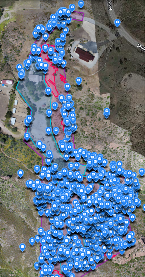
With a drone and 3D mapping software, we can survey a property of that scale in one to two hours. The aircraft captures thousands of overlapping images during the flight. Those images are processed into a single seamless map of the entire property, a complete aerial view with geographic precision.
We then work through that map to create documentation that law firms and adjusters can use directly:
Property boundary overlays. Often in coordination with a licensed surveyor who establishes the legal boundaries first, we create a visual overlay that shows exactly where the property lines fall and what the fire did within those boundaries.
Vegetation zone mapping. We identify and document the zones where vegetation existed before the fire, using pre-fire and post-fire comparison where available.
Tree counts with GPS location. Every tree on the property is counted and its location recorded with GPS precision. This matters because each tree carries an assigned monetary value in a damage claim. A property with 200 mature trees has a different claim value than a property with 80. We give you the exact number, located on the map, in a format that can be submitted as evidence.
Structural damage documentation. Aerial coverage of structures, foundations, outbuildings, and infrastructure from angles that ground photography cannot provide.
The result is a documentation package that presents the full scope of loss in a form that is clear, precise, and difficult to dispute.
Who We Work With
We work directly with law firms handling wildfire litigation, and with homeowners who are either building a claim or supporting a case that is already in litigation.
For law firms, we provide documentation packages that are structured for use in depositions and courtroom presentation. The aerial maps, the GPS-located tree counts, the boundary overlays: all of it is formatted to be introduced as evidence. We have provided deposition support on cases arising from both the Woolsey and Thomas fires.
For homeowners, we work to make the documentation process as straightforward as possible. We know the emotional weight of what you are dealing with. We have been there. Our goal is to give you the clearest possible picture of what you lost, in a format that protects your right to full compensation.
What We Have Seen
In connection with the Woolsey Fire, we worked on approximately 15 cases. On the Thomas Fire, we worked on two. In both situations, the properties we documented were large enough that ground documentation alone would have missed significant portions of the loss, vegetation zones in areas difficult to access on foot, structures set back from the main road, tree populations spread across acreage that needed to be counted systematically, not estimated.
The Palisades Fire has created a new round of loss across the region. If you or your clients are navigating property damage claims arising from recent Southern California wildfires, we are available to discuss documentation needs.
Book a Consultation
If you are a homeowner with a pending insurance claim or litigation matter, or a law firm handling wildfire loss cases in Malibu or greater Los Angeles, contact us to discuss your documentation requirements.
We understand the process from every angle. We have lived it.
Book a consultation to discuss your wildfire documentation needs.
Documenting wildfire damage in Los Angeles or Malibu?
We have documented over a dozen Woolsey Fire properties for litigation and insurance claims. We know what attorneys and adjusters need. Call us to discuss your documentation requirements.
Or fill out the contact form. We respond the same day.