September 17, 2026 ·3 min read
By Jaron Denson, owner and aerial director of photography at Drone Tech Aerial. FAA Part 107 remote pilot, flying productions in Los Angeles since 2012.
Aerial Documentation for Wildfire Rebuilds: From Damage Claims Through Construction Progress
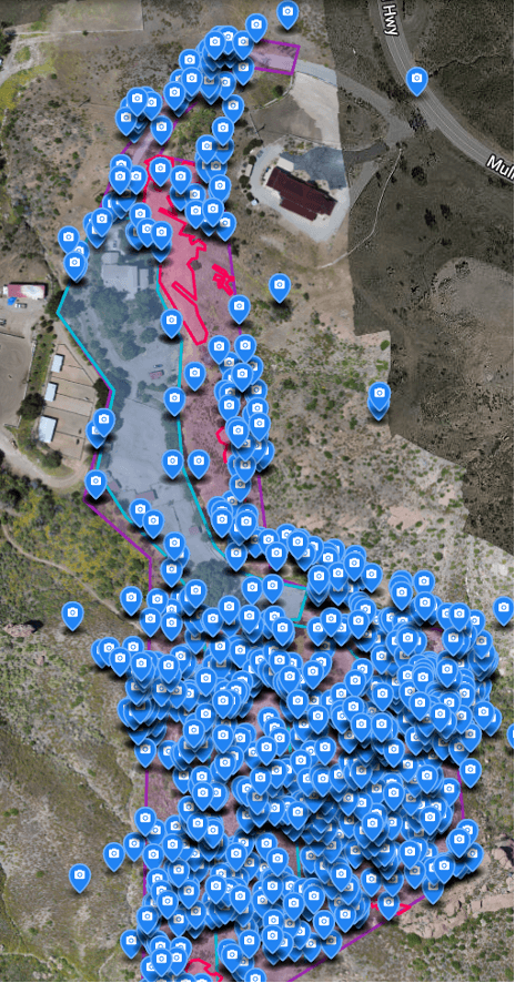
The documentation need does not end when a wildfire claim settles. For thousands of Southern California property owners now rebuilding after the January 2025 fires, it changes shape: from proving what was lost to tracking what is being restored, and protecting the owner’s position through a rebuild process that can run for years. We lost our own home and business in the 2018 Woolsey Fire and rebuilt, and the documentation service we operate today covers the full arc we lived through. This post covers the rebuild half of that arc, for homeowners, the attorneys representing them, and the professionals managing their reconstruction.
Why the rebuild phase needs its own record
A rebuild is a long sequence of parties doing work on your land: debris removal contractors, remediation crews, graders, utility crews, builders. Each transition is a point where the property’s condition should be recorded, because each is a point where disputes later become expensive. Aerial documentation captures the whole parcel at each milestone, in a form that is dated, georeferenced, and comprehensive in a way that phone photos from the driveway are not.
The moments worth capturing on most rebuild timelines:
- Pre-debris-removal baseline. The condition of the loss site before any material leaves. This protects the scope of the claim, supports supplemental claims when additional damage is found, and creates the reference against which removal is verified.
- Post-debris-removal and grading. Confirmation that removal is complete, that grading matches what was contracted, and that no fill, foundation remnant, or hazard was left behind. Owners have discovered scope gaps at exactly this stage; an aerial map makes the conversation factual.
- Construction progress at draw milestones. Lenders releasing construction funds against completion stages, and owners paying builders against invoices, both benefit from an independent visual record of the state of the build at each draw.
- Completion and final condition. The closing record of the restored property, alongside pre-fire imagery where it exists.
We produce these as orthomosaic maps assembled from thousands of overlapping aerial images, the same mapping methodology we use for litigation documentation: a complete, high-resolution, geographically precise view of the parcel, repeatable flight to flight so the same angles compare cleanly across months.
The claims tail: supplementals and disputes
Insurance involvement rarely ends at the initial settlement. Supplemental claims arise when rebuild work reveals damage the original scope missed, from foundation and soil issues to tree loss that only becomes countable once debris clears. Our documentation work on roughly fifteen Woolsey Fire cases and two Thomas Fire cases, including deposition support for the law firms involved, taught us what adjusters and opposing experts challenge: undated evidence, partial coverage of the parcel, and records that cannot be located precisely on the property. Aerial documentation with GPS-tagged imagery and chain-of-custody flight logs answers all three, which is why attorneys bring us in while matters are active rather than after the record has gaps.
For vegetation specifically, the rebuild phase is when tree counts become concrete. Each lost tree carries assigned value in a claim, and post-clearing aerial mapping lets every removal be counted and located rather than estimated. The methodology is described in our Woolsey Fire documentation post.
A note on active fire zones
One boundary we hold without exception: we do not fly during active fire incidents. Temporary Flight Restrictions over active fires exist to protect firefighting aircraft, and we treat fire TFRs as absolute. Documentation work begins when the incident is over, the restriction lifts, and access is lawful. Property owners occasionally ask for imagery while a fire is still burning nearby; the answer is no, and any operator who says otherwise is telling you something important about how they run the rest of their operation.
Where this fits in our practice
Wildfire documentation is not an add-on service for us. We went through the loss, the itemized claim, the litigation, which we won, and the rebuild, and we built the service on that experience. The FAA Part 107 licensing, the $5M per-flight aircraft liability coverage, and the court-ready documentation standards are described on our aerial documentation service page.
If you are rebuilding after the Palisades, Eaton, or another Southern California fire, or you are an attorney or builder working with owners who are, book a consultation. We will map your timeline to the documentation milestones that protect you, and we respond the same day.